Showing posts with label Peru. Show all posts

Friday, July 4, 2014

Visiting Machu Picchu

Machu Picchu may be one of the most well-known monuments on Earth, but there are still many who have yet to discover the beauty of this place. Here are some of the reasons why you should consider adding this destination on your wishlist.


What is Machu Picchu?

This is an easy question, but I am sure there are some who still don’t know much about this famous archeological site. Machu Picchu was once a thriving city of the Incas, a stronghold whose stone walls defended the Inca Empire for years. Made entirely out of stone, the city is made up of countless homes and palaces. While archeologists today are still trying to find out if Machu Picchu was a military base, a ceremonial site, or simply a retreat for the wealthy, one thing is certain: the legendary “Lost City of the Incas” (and UNESCO World Heritage site) is worth visiting.

 Where is Machu Picchu?

Located high in the Andes (at over 2000 m), this Peruvian site was the center of a series of trails. Machu Picchu is also surrounded by the Urubamba River, which is known for being extremely windy and difficult to navigate. Tropical forests complete the appearance of a city with a unique, yet isolated position.

 Who discovered Machu Picchu?

When reading about the inhospitable landscape, you might immediately wonder who was able to travel to such a remote area, and find the city in the first place. Funnily enough, while the locals knew of the site, Spanish conquistadors were never able to find it.

It wasn’t until 1911, when Hiram Bingham, a professor at Yale University, first laid eyes on the mysterious city. Famously, Bingham ended up “discovering” Machu Picchu by accident – he was supposedly on a mission to discover an entirely different city. Nonetheless, Machu Picchu soon became known to the world.

When should I visit Machu Picchu?

While the site is open year-round, it is highly recommendable that you visit Machu Picchu between May and September, the period also known as the dry season. July and August are the busiest months, and while travelling during peak season offers you many travel options, it is also very crowded.

Travelling during the rainy season may not be so hectic, but it also restricts the number of ways to travel to the Lost City. If you’re not afraid of a little rain, November and April are ideal, as the weather is far too unpredictable in the remaining months.

How do I get to Machu Picchu?

Due to its location, Machu Picchu might seem difficult to reach at first. However, after flying to Peru, it is only a matter of time until you find out how easy it is to get to the Lost City. During the dry season, bold tourists can try hiking, zip lining, or biking, but there are many other possibilities available. If you want to travel comfortably, then you can get to Machu Picchu via bus, minibus, or even train. There are many travel agencies which offer a variety of tours, so it’s only a matter of finding what is best for you.

Why should I visit Machu Picchu?

Why not? It’s a unique experience in which you can learn about an interesting culture, while also enjoying the breathtaking Peruvian landscape. If planned wisely, a trip to Machu Picchu (and its surroundings) can be done even if you’re on a budget. Get ready for the adventure of a lifetime!

Monday, June 18, 2012

Cusco, Peru

The city of Cusco is located in a valley at an altitude of 3500 meters before coming of the Spaniards, there was the capital of the Incas in the city had many temples, later destroyed by the Spaniards. At the site of the largest Catholic churches were built ...


This preserved foundation of the former Temple of the Sun - the main temple of the city. On the field in front of him, according to the Spaniards, was a garden of golden trees in full size ... Now on this spot a Catholic cathedral.

It used to be that, apart from the foundation of the ancient temple there was nothing left. But then, during the earthquake collapsed the walls of some churches. And behind them were found surviving walls of temples of the Sun, Moon and Lightning. Now they are open and laid up and can be seen.

In the center of the church yard - the sacred stone. The Incas believed that this cup in the morning sun drinks the water. Earlier this cup, too, was covered with gold.


The ancient walls stood in the earthquake that destroyed a new structure of Spaniards, not by accident. The Incas were very skilled builders. Their buildings are highly mathematical precision.


Instead of laying the stones of the old bricks, they are simply plastered and painted. Here the left of the painting, so you can see, looked like "disguised" the wall at the time of the conquistadors.


Resolution of the City Hall, all the houses in Cusco must be covered with tiles!


Night in Cusco is very comfortable. Here you can calmly walk the streets at night.


Tuesday, November 8, 2011

Peru and Costa Rica Advance Gastronomic Tourism


2 Latin America countries at once have expressed the desire to attract the attention of travellers to their gastronomic heritage. In particular, recently the minister of tourism of Costa Rica, Allan Flores submitted a plan to promote national cuisine as tourist attractions.

Costa Rican cuisine is based on a mixture of Spanish and Indian cuisines: the beans, rice and meat, plus a lot of herbs, vegetables and spices. Preparing all of the unique local recipes. The project put forward by businessmen and government officials, aims to promote cooking Costa Rican cuisine in the hotels and restaurants. This program will enhance the preservation of traditions of the country, believe in the Ministry.

In addition, the President of Peru, Ollanta Humala in his recent speech at the UN General Assembly declared its intention to apply to UNESCO to make a national cuisine in Peru World Heritage List.

Submitted to UNESCO documents indicate the existence of ethnic cuisine in pre-Incan period. In addition, the application shows the inextricable link between the living cuisine and contemporary culture of the country, which is manifested in the daily activities of thousands of people of various professions in Peru. According to the President, Peruvian cuisine is the joint creative work of all its citizens, where every Peruvian can contribute.


Wednesday, August 17, 2011

Machu Picchu


The ancient city of Machu Picchu (Quechua: Machu Pikchu, in translation - the "old peak"), as claimed by some archaeologists to have been founded the Inca ruler Pachacutec. The city was built as the residence of the ruler of a hundred years before the conquest of his empire, around 1440. In 1532 the Inca Empire was invaded the Spanish conquerors. That same year, residents of the city mysteriously disappeared.

More than 400 years the city was abandoned. The city was re-opened about a hundred years ago. July 24, 1911 the city was found by an American researcher from Yale University professor Hiram Bingham.

The city is located on the territory of modern Peru at the top of the ridge at an altitude of 2450 meters above sea level, dominating the valley of the Urubamba River.


Friday, March 25, 2011

Nazca Lines


Nazca Desert - is a desert plateau on the southern coast of Peru. Nazca received worldwide fame due to an ancient Indian culture, which flourished in 3 - 8 century BC. It were they who created the famous
Nazca lines-drawings, which are visible even from space.

Nazca were farmers and were treated with fertile plains along the Pacific coast of Peru. They left no evidence of their writing system: all the known facts about them have been obtained by studying the burial places of the Nazca and found objects.

Civilization of the ancient Nazca Indians got its name from the river in a valley which had been discovered monuments of this culture - the mysterious giant drawings. These pictures are mainly located on the cliffs along the Rio Grande and its tributaries, in the extremely arid zone between the valleys of Ica and Nazca.

Who and what created these images still remains a mystery. The world's largest product of graphic art encompasses an area of ​​520 sq. km. Open to the world they were in 1941 when they went to study American archaeologist Dr Paul Kosok from Long Island University. These lines, drawn in red rock desert, represent more than 100 known plants, animals and simple geometric shapes, as well as a scattering of obscure, not related to each other straight lines.

All figures in the desert were performed by one and the same way: the surface layer of reddish rock continuous line scratched before lying beneath a pale yellow rock. Apparently, this was done manually. The lines are so straight that there is an assumption that the staves were used to draw them. Still remains a mystery how a painter could so accurately adhere to plan and achieve the effect of straight line at such large distances.

According to one theory is that all these shapes and lines represent "the largest astronomy world book." These images show the location of stars and constellations at different times of the year used by ancient Nazca to determine the exact time of plowing, sowing and other important "phases" of the agricultural cycle. On another, more modern version, is that some of the mysterious lines can actually point to the underground water sources. The ancient inhabitants of Nazca, perhaps, have noted the location of their distribution system of water supplies, because during the drought they were more reliable sources of potable and irrigation water than the rivers.

How to see the Nazca drawings?
To do this, go to the provincial Peruvian town located about 450 km south of Lima. Here, from the airport every 5-10 minutes rises a little four-seater plane, at an altitude of several hundred meters to make a half-circled figures.


Thursday, March 24, 2011

Titicaca Lake

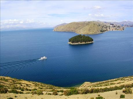
Titicaca Lake - a lake in the mountains of the Andes, located on the border between Peru and Bolivia, the Altiplano plateau. This is the largest lake in South America and the world's highest navigable lake.

25 rivers flow into the lake which are flowing down from the glaciers surrounding the Altiplano and follows the river Desaguadero. Water salinity is about 1 ‰, so Titicaca is a freshwater lake.

Titicaca Lake is the largest alpine lake in the world, it 'climbed' to a height of 3,812 meters. Alpine basin is formed as a result of ancient tectonic events, it is assumed that the lake was part of a larger body of water, sea or ocean.

There are different opinion on how to translate the name of the lake. "Titicaca Lake" is translated from the Aymara means "sacred stone". Another legend says that Lake Titicaca - is a "stone cougar", if you look at him with a bird's-eye view, you can see the outlines of this animal, surrounded by mountains. The second translation is "tin box". This justifies the name of a specific color of the water in the pond.

Tourists familiar with Lake Titicaca in Puno start - a city founded in 1668 near the mine, where silver was mined. Beside the lake, and tourists interested in the islands, which are naturally swim on the lake with all its population. A total of 32 natural lake of the island. 6 of them became a shelter for foreign tourists, they are called - "the island hotels". This Estebes, Amangani, Taquile, Soto - in the Peruvian part of the lake and Sun and Moon Islands are in the territory of Bolivia.

In addition to these "settled" Islands in the Bay of Puno there are also 44 floating islands - artificial one. They are collectively known as "Uros" - on behalf of their inhabitants - the Indians, numbering about 1200 people.


Tuesday, May 18, 2010

Titicaca Lake


Titicaca Lake: on the border of Bolivia and Peru

Lost in the Andes and covered with legends, Titicaca awakens the imagination, makes one want to visit its shores. But the real attraction here is not visible - a few dozens of floating islands.


The lake itself had contrived to climb to an altitude of 3820 meters. Occupying the lower part of the highlands stakes Titicaca belongs to 2 countries - Peru and Bolivia. The maximum width of 80 kilometers, and the total surface - 8300 square kilometers, most of whom are located in Peruvian territory. Tourists traveling to Peru, familiarity with the lake beginning in Puno - a city founded in 1668 near the mine, where silver was mined. The town stands on a hillside on the slope increases, and he has nowhere else to grow. For three centuries, the population had accumulated to 100 thousand. There is speculation that the Titicaca - part of the ocean was cut off from him after the lifting of the Western Cordillera Oriental. This theory is confirmed by the presence on the Bolivian gigantic salt mines.

But most tourists are interested in the islands, which naturally float on the lake with all its population. It's hard to believe but it is true: Hundreds of people are born, grow up, spend their entire lives and leave them without leaving these islands, floating in the cool depths of nowhere over the lake.


"Lake Titicaca" in translation from the Aymara means "sacred stone". He was in the temple of the sun, and he in turn - on the island of the Sun, the largest of the entire lake archipelago. Unfortunately, from the temple itself remained only ruins. Tempered rather wayward Titicaca. Most steep it in the rainy season - from December to February. At this time, the river brings a lot of the red and the color of water in the lake is changing. In February, the level of the mirror is increased by half a meter, and maybe more. In the flood Titicaca overflows its banks, flooding fields and even the lower part of Puno, along with the pier. And when zaduyut winds up a big wave. Besides the lake there are ebbs and flows like the ocean, but water level fluctuations were modest - up to 80 centimeters. And yet, in such circumstances to live on the islands drifting, perhaps quieter than on the coast.